|
Pattani (ปัตตานี)
Capital of a province (map) of the same name situated on the east coast of the Thai peninsula in South Thailand, 1,055 kms from
Bangkok. Its population of approximately 41,000 is largely Muslim and the city has a strong Islamic character. On the outskirts of the city stands the Masjid Klahng Pattani, the Pattani Central Mosque (map
-
fig.), the largest Muslim house of prayer in Thailand
(map
- fig.). Many southern Thais are in fact Malay by race, tongue
(Yawi) and culture, and are known as Malay Thais or Pattani Thais. Their history can be traced back to the ancient Malay
Kingdom of Langkasuka in the 2nd century, up until the Pattani Sultanate of the 19th century, when it was an independent Islamic
Kingdom. In the 7th century, it was part of the
Mahayana Buddhist Empire of
Srivijaya,
but during the
Ayutthaya
Period
it became a vassal to the Siamese court, a status manifested by sending silver
and golden miniature trees to its kings. After the fall of Ayutthaya to the
Burmese in 1767, the very existence of Siam was in doubt and with the
establishment of the
Chakri Dynasty and
the beginning of the Bangkok Period, especially from the reign of King
Rama I to King
Rama III,
Siam
sought to consolidate its power and strengthen its position by trying to incorporate the Pattani
State into its Kingdom.
This was seen as an important strategic issue by the Siamese, who wanted to
ensure control of the southern peninsular coast, which enabled them to attack the
Burmese in the rear from the South. Resisting the military attacks of the Siamese many Malay Muslim villagers were forcibly uprooted and transported to Bangkok. In 1785, royal troops fought in the West of the country against the Burmese army near Meuang Faai. After this campaign, they retreated to
Songkhla where they learned of a Pattani rebellion against
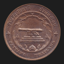
Rattanakosin. The troops were given new orders and sent to Pattani, which they recaptured confiscating two cannons. They offered the largest one, having a length of 3
wah
(6 meters) and named ‘Phaya
Thani’
(fig.), to the
King. In 1832, Sultan Ahmad Tajuddin of Pattani also tried in vain to liberate his land from Siamese control. Finally, by the virtue of the
Anglo-Siamese Treaty of 1909, the southern region was divided between the Thai and British colonisers in
Malaysia, in which Britain formally acknowledged the Pattani
State as a part of Siam. In total, five provinces, i.e. Pattani,
Yala,
Narathiwat, Songkhla and
Satun, were forced to accept Siamese authority. Tengku Abdul Kadir, the last ruler of the Pattani
State, led a revolt but was captured and imprisoned for ten years. He later went into exile in Malaysia.
Today, there is still a small but active Muslim separatist movement, which –after
being dormant for many years– erupted again in January 2004 and tries to liberate the deep South from Thai rule. This province has twelve
amphur.
It's attractions include the
Masayid Kreu Se (fig.)
and
Lim Ko Niau shrine (fig.).
See also
Pattani data file.
回


|